
הקדמה
This manual provides essential instructions for the setup, operation, maintenance, and troubleshooting of your Lowrance iFinder Expedition C Plus Waterproof Hiking GPS. Designed for outdoor navigation, this 16-channel handheld GPS unit features a color display, electronic compass, barometric altimeter, and MP3 player capabilities. Please read this manual thoroughly to ensure proper use and to maximize the performance of your device.
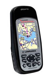
Image of the Lowrance iFinder Expedition C Plus handheld GPS unit, showcasing its color display and button layout.
סעטאַפּ
- ייַנמאָנטירונג פון באַטאַרייע: Open the battery compartment cover on the back of the unit. Insert the required batteries (not included) according to the polarity indicators. Close the cover securely to maintain the waterproof seal.
- Memory Card (MMC/SD) Installation: Locate the memory card slot. Insert the provided MMC/SD memory card, ensuring it is correctly oriented. This card is essential for storing additional maps and data.
- ערשטע איינשטראָם: Press and hold the power button until the device screen illuminates. Follow any on-screen prompts for initial setup, such as language selection and time zone.
- MapCreate USA Topo Software Installation: For custom, high-detail mapmaking, install the exclusive MapCreate USA Topo mapping software on your personal computer. Use the provided MMC/SD card reader with a USB connector to transfer maps to your device.
אַפּערייטינג ינסטראַקשאַנז
יקערדיק נאַוויגאַציע
- GPS סיגנאַל אַקוויזישאַן: For optimal performance, use the device outdoors with a clear view of the sky. The 16-channel GPS receiver will automatically acquire satellite signals.
- מאַפּע Viewינג: Use the directional pad to pan across the map. Zoom in and out using the dedicated zoom buttons. The 2.83-inch diagonal color TFT display with 320 x 240 resolution provides clear map details.
- Waypoint Creation: Mark your current location as a waypoint by pressing the 'Mark' button. You can name and save these points for future reference.
אַוואַנסירטע פֿעיִקייטן
- סקאַוט מאָדע: Activate 'Scout Mode' to mark area perimeters and create custom borders on your map. This is useful for defining hunting grounds, property lines, or exploration areas.
- עלעקטראָניש קאָמפּאַס: The built-in electronic compass provides accurate heading information even when stationary. Calibrate the compass periodically as instructed on-screen.
- באַראָמעטרישער אַלטימעטער: The integrated barometric altimeter provides precise altitude readings and can track changes in atmospheric pressure, useful for weather forecasting.
- Mp3 שפּילער: The device includes MP3 player capabilities. Load your favorite audio files onto the MMC/SD card to enjoy music during your expeditions.
- מיקראָפאָן: Utilize the built-in microphone for voice notes or other audio recordings.
וישאַלט
- רייניקונג: ריין די מיטל מיט אַ ווייך, דamp שטאָף. פֿאַרמײַדט אַברייסיוו רייניגער אָדער סאָלווענטן וואָס קענען שאַטן דעם עקראַן אָדער קasing.
- וואָטערפּרוף קער: While the iFinder Expedition C Plus is waterproof, ensure all port covers and the battery compartment are securely closed before exposure to water. Do not submerge the device beyond its rated depth or for extended periods.
- סטאָרידזש: ווען נישט אין באַנוץ פֿאַר לענגערע פּעריאָדן, אַרויסנעמען די באַטעריעס צו פאַרמייַדן ליקאַדזש. האַלטן די מיטל אין אַ קיל, טרוקן אָרט אַוועק פון דירעקט זונשייַן און עקסטרעמע טעמפּעראַטורן.
- ווייכווארג דערהייַנטיקונגען: פּעריִאָדיש קאָנטראָלירן די לאָווראַנס webזייטל פֿאַר פירמווער דערהייַנטיקונגען צו ענשור אָפּטימאַל פאָרשטעלונג און אַקסעס צו נייַע פֿעיִקייטן.
טראָובלעשאָאָטינג
- מיטל נישט פּאַוערינג אויף:
- קאָנטראָלירט די אָריענטאַציע פון די באַטעריעס און זיכערט זיך אַז זיי זענען פריש.
- זיכער מאַכן אַז די דעקל פון די באַטעריע אָפּטייל איז גאָר פֿאַרמאַכט.
- דזשי-פי-עס באקומט נישט קיין סיגנאל:
- גיי אריבער צו אן אפענעם פלאץ מיט א קלארן view פון הימל.
- לאָזט עטלעכע מינוט פֿאַר דעם אַפּאַראַט צו באַקומען סאַטעליטן.
- Screen Issues (Dim/Unresponsive):
- סטרויערן די באַקלייט סעטטינגס.
- Perform a soft reset (refer to the device's on-screen menu for instructions).
- Map Data Not Displaying:
- Ensure the MMC/SD card is properly inserted.
- Verify that map files are correctly loaded onto the memory card using MapCreate USA Topo software.
ספּעסאַפאַקיישאַנז
| שטריך | דעטאַל |
|---|---|
| מאָדעל נומער | 112-87 |
| סאָרט | לאָוראַנס |
| גפּס טשאַננעלס | 16-קאַנאַל |
| ווייַז טיפּ | Color TFT with white LED backlight |
| פאַרשטעלן גרייס | 2.83 אינטשעס (דיאַגאָנאַל) |
| ווייַז האַכלאָטע | 320 X 240 בילדצעלן |
| דימענשאַנז (ב x ה x ד) | 5.6 X 2.5 X 1.2 אינטשעס (14.2 X 6.35 X 3.05 סענטימעטער) |
| וואָג | 8.7 ounces (0.25 kg) / 1.11 kg (shipping weight) |
| מענטש צובינד אַרייַנשרייַב | מיקראָפאָן |
| זיקאָרן קאַרד שטיצן | MMC/SD |
| UPC | 042194528304 |
וואָראַנטי אינפֿאָרמאַציע
Warranty details for the Lowrance iFinder Expedition C Plus are typically included with the product packaging or available on the official Lowrance website. Please refer to these resources for specific terms, conditions, and registration procedures.
שטיצן
For further assistance, technical support, or to download the latest software updates, please visit the official Lowrance website. You may also find FAQs and additional resources there to help you with your iFinder Expedition C Plus GPS unit.